

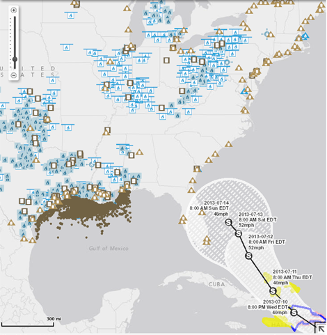
Screen capture of the interactive map from U.S. Energy Information Administration (EIA) shows current predicted path of tropical storm Chantal as well as the nation's energy resources.
As the most active part of the hurricane season approaches, the U.S. Energy Information Administration (EIA) has rolled out helpful online resources which show not only the projected path of storms but also how the storm might impact energy sources and infrastructure. Hurricanes can affect the United States's energy infrastructure, especially when storm paths traverse offshore production rigs and pipelines in the Gulf of Mexico, coastal refineries, power plants, and energy import and export sites.
The agency's interactive maps use real-time data feeds from the National Hurricane Center and combine that data with more than 20 map layers, which display the United States' energy producing sources - gas and oil plants - as well as electric utilities. This new tool allows uses to better see and understand the potential impact of a storm.
"This new mapping capability combines detailed energy infrastructure information with real-time tropical storm information from the National Hurricane Center," said EIA Administrator Adam Sieminski.
The new maps are now online at http://www.eia.gov/special/disruptions/. Presently, the public can see the current predicted path of tropical storm Chantal, moving from the Caribbean's Leeward Islands toward the Atlantic coast of Florida. As the National Hurricane Center revises its predictions, the maps will be updated immediately.
EIA, which is the statistical and analytical agency within the U.S. Department of Energy, collects, analyzes, and disseminates independent and impartial energy information.
Bookmark our Disaster Recovery channel for more stories on disasters and disaster planning.


